Sunday, June 05, 2005
Saddleback Butte State Park
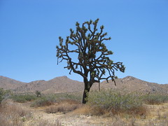
Today Becky and I check out Saddleback Butte State Park located about 20 miles east of Lancaster, CA. To get there we headed East on Avenue J. Driving there we could see the mountains off in the distance that we would soon be standing on. The elevation at the summit of Saddleback Butte is 3,651 feet. This stands 1,000 feet above the bottom land of the Antelope Valley. From the parking lot it is 1.6 miles to the summit. The hike starts off on flat land for about one mile then it starts to head up. This hike must be real nice in the spring when all of the wildflowers display their colors. Today there was not too much color out there. It was a nice hike though and we had plenty of water with us. The picture to the right show Saddleback Butte in the background. I really enjoyed seeing the snow capped mountain to the south. It is a strange feeling to be hiking in the warm desert and seeing snow capped mountains in June. At the top of Saddleback Butte it was very windy. We checked out the view and got a couple of pictures and then headed back. If you click on the picture to the right you will be able to see the seven other pictures I took on today's hike.
# posted by pault27 @ 8:46 PM 
![]()
