Saturday, May 28, 2005
Paso Robles Wine Country
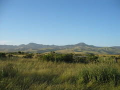
Heading to and from San Simeon State park we drove through the Paso Robles Wine Country. This is a beautiful area and has more than 70 wineries and more than 200 vineyards. We drove through this area on highway 46 and there is a group of wineries on this stretch that have joined together to form a passport promotion. This passport promotion includes 17 wineries along highway 46. After you taste wines at the participating wineries they will stamp your wine passport, which is available at the wineries. Check out the passport promotion website to get more information. You can also check out their home page to get more information about the wineries on highway 46. This is a real nice area to drive through and stop at wineries along the way. Those who were not driving on our trip got to sample some wines at a few different wineries in Paso Robles Wine Country. We stopped at Bonny Doon Vineyard, Peachy Canyon, Castoro Cellars, and Mastantuono Winery. I have linked their websites to their names so check them out. Now, only being in California for three weeks, I would have to say that highway 46 is a real nice view with beautiful rolling hills and vineyards. At one section of highway 46 you can see the ocean and Morro Rock. I was not able to get any pictures since I was driving. It would have been difficult to get all of the stunning countryside into a picture.
# posted by pault27 @ 4:02 PM 
Friday, May 27, 2005
Antelope Valley Links
I just came across another website with some information about the Antelope Valley. Click HERE. I also found a website with some more information about the communities in the Antelope Valley. Click HERE to see that page. There is also a website with frequently asked questions about the Antelope Valley that looks like it has some interesting information. Click HERE to see the frequently asked questions page.
# posted by pault27 @ 9:51 AM
Moonstone Beach
A few miles south of San Simeon State Park is Moonstone Beach. This is a very nice beach as well. The nice thing about this beach is that it has a boardwalk all along the beach. Along the boardwalk there are a lot of nice flowers as well so it makes for a very nice walk. As we got to one part of the beach we noticed a bunch of seals out in the water. They were sunning on the rocks near shore.
# posted by pault27 @ 9:43 AM
Wednesday, May 25, 2005
Morro Bay
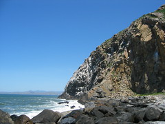
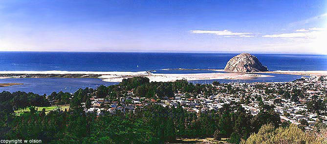
On the Saturday of our camping trip we decided to check out Morro Bay. We passed this area on our way to the camp site and saw a huge rock just off shore called Morro Rock. We took a little drive to the area and to my surprise you could drive out to the rock. We parked the car and checked out the area. There was a surf competition going on so we watched that for a little while. The surf competition was on the north side of the rock. To the south side of the rock there were a bunch of smaller rocks, relatively speaking, that broke the waves. This left a nice calm area for people to kayak on that side of the bay. Check out this picture of the waves hitting the rocks. Click HERE. We did notice a lot of signs stating no rock climbing on this massive rock. It must be a real nice view at the top but I guess the view is left for the birds. I was not able to get a picture of the entire rock but click HERE to see one. You can also check out the web site for Morro Bay to learn more, click HERE.
# posted by pault27 @ 4:06 PM
Tuesday, May 24, 2005
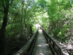
Trail in San Simeon State Park
This picture was taken on the trail in San Simeon State Park on Willow Bridge. This picture was taken at Fern Gully just before we entered into the pine forests. It was very interesting to hike along these trails in the forest so close to the shore.
# posted by pault27 @ 9:54 AM
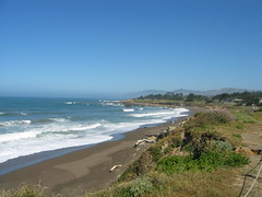
San Simeon State Park
This past weekend a group of us went camping at San Simeon State Park. This park is located about 215 miles northwest of Lancaster, CA. It is located on the central coast of California about 35 miles north of San Luis Obispo. It was a very pleasant drive out to this state park from the Antelope Valley. We took 138 to 5 to 46 to scenic Highway 1. The ride along 46 was also very nice with all of the rolling hills and vineyards. This picture was taken just behind our campsite and is located a mile from the coast. At our campsite we could hear the ocean as well as coyotes at night. The sounds of turkeys gobbling woke me up in the morning. It was a very nice time camping there. With the shore only a mile from the campsite it was nice to walk down there. The shore was a mix of dirt and rocks but nice to walk along. There are also trails inside the park that take you through pine forests. It was strange to see a sign warning us about mountain lions but luckily we did not see any of them. We did see a couple of deer on our drive out of the park Sunday morning. I think they were black-tail deer. You can learn more about the park by clicking here.
# posted by pault27 @ 9:50 AM
Monday, May 23, 2005
Sharing Photos
As you can see I am able to share my digital pictures with you on this blog. I am using Flickr to do this. If you would like to set up a free Flickr account click here. There are security settings you can set so your photos can not be seen by everyone. In order to attach a photo to a blog the photo must be public though. The process is easy to get your photos on Flickr. You will just need to upload the digital photos. There are a lot of great features Flickr has to offer and I am just beginning to learn them. Check out this blog post I came across about features of Flickr.
# posted by pault27 @ 11:24 AM
Hermosa Beach Cam
While we were at Hermosa Beach the other day some fog rolled in around lunch time. We heard about a beach cam located near Good Stuff Restaurant and thought that would be a good place to grab a bite to eat. While waiting for our table the camera got a picture of us. The Strand Cam archives the photos on the internet so if you go see if it got your picture. It is a great place to grab some food and has a nice outdoor dining area. After we ate our delicious lunch the sun returned.
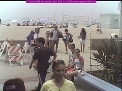
# posted by pault27 @ 11:13 AM
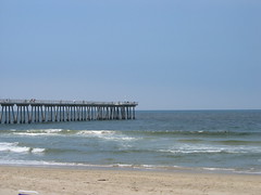
Hermosa Beach
One of the great things about California is all of the beautiful beaches. A beach that is listed as a wonderful beach to visit in a lot of books is Hermosa Beach. Hermosa Beach is located about 80 miles south of the Antelope Valley. It is a nice sandy beach with sand volleyball courts. There are also surf shops and other shops to check out along the beach.
# posted by pault27 @ 10:40 AM
Sunday, May 22, 2005
Antelope Valley and Beyond
I have just changed the description of this blog to "Information about the Antelope Valley and Beyond." It was previously "Information about the Antelope Valley and moving across the country." Although I have moved across the country I think this blog will be more like this new description. These past couple of weekend I have traveled outside the Antelope Valley and would like to inform you not only of the Antelope Valley, where I now live, but also the surrounding areas and the beautiful things to see and do in this part of the country. I have some good materials to share with you in my upcoming posts so check back soon. It is hard to believe I have been in the Antelope Valley for over two weeks now.
# posted by pault27 @ 8:46 PM
Thursday, May 12, 2005
Rabbit in the Prime Desert Woodland Preserve
Attached here is a photo of a rabbit that I saw while walking in the Prime Desert Woodland Preserve. There is a lot of wildlife to see on these trails. I have seen mostly rabbits and this one allowed me to get a picture. They move quick heading towards cover. There are also a lot of birds in the preserve. Yesterday I saw two big ravens but didn't have my camera. It is nice to see all this wildlife a short distance from the urban area of Lancaster, California.

# posted by pault27 @ 12:36 PM
Prime Desert Woodland Preserve
The other day I was exploring the area and I came across a nice nature preserve. The Prime Desert Woodland Preserve is located in Lancaster, California where K8 meets 35th St. West. This is a nice area with nature trails and information posted along the trail about the surrounding ecosystem. It is a nice place to go for a relaxing walk and enjoy nature. The two main plants in this preserve are the Joshua Tree (see picture) and California Juniper. It is rare to find these two plants growing in the same area since they have different growth requirements. The rainfall and soil conditions in the Antelope Valley, Western Mojave Desert, allow the Joshua Tree and California Juniper to both grow here. The Joshua Tree is found only within the Mojave Desert. Technically it is not a tree but rather a part of the agave family. The Joshua tree is an important part of the high desert ecosystem providing food and shelter for birds, reptiles, insects, and small mammals. If you are in the area I would suggest you check out this nice preserve. There are a couple of looped trails to choose from.

# posted by pault27 @ 12:30 PM
Tuesday, May 10, 2005
Finding Hikes in the Area
One of the things I like to do in my spare time is go for a nice hike. Now that I am in a new area of the country I have to find out where to go. I found a website that will help me out. Localhikes.com You can simply enter in your zip code and a list of hikes in your area will appear. The zip code for Lancaster is 93534 if you want to see the hikes nearby.
# posted by pault27 @ 2:55 PM
Monday, May 09, 2005
Arrive in the Antelope Valley
I have arrived in the Antelope Valley. I flew in on Thursday, May 5th. I had a nice flight out although when I arrived in LA it was cloudy and raining a little. When I arrived in Lancaster I was tired from the day of traveling and had a lot of unpacking to do on Friday. Saturday and Sunday were nice days and I began to explore the area a little bit. I have a AAA Tour Book for Southern California and it says that Lancaster has a population of 118,718. The elevation of Lancaster is 2,355 feet. It is so nice to see the big mountains that surround the area. I can even see snow capped mountains in one area to the south. The Antelope Valley is located between the Sierra Madre & San Gabriel Mountains, south of here, and the Tehachapi Range Northwest of here.
# posted by pault27 @ 9:00 AM
Sunday, May 01, 2005
Location of the Antelope Valley
The Antelope Valley is located an hour to an hour and a half north of Los Angeles, California. The two main cities of the Antelope Valley are Palmdale and Lancaster. You can view a map of Palmdale and Lancaster by clicking on their links. You can also view satellite images of the areas through those links by clicking on "satellite" which will show up on the upper right hand side of the page. There is some more information about the area click Here.
# posted by pault27 @ 3:53 PM
![]()
